Overview
Once you read through this, won't your "resolution" get higher when looking at maps around Nagoya?
Thoughts When Looking at Maps of the Nōbi Plain
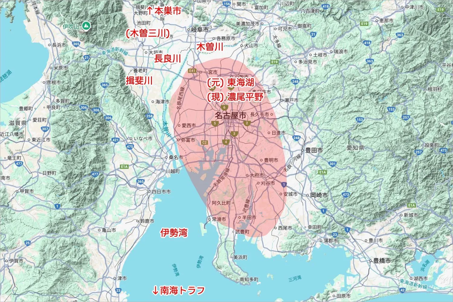
- The Nagoya area is higher in the east and lower in the west. This is due to the Nōbi Tilting Block Movement.
- Because of that, the Kiso Sansen (Kiso Three Rivers) also flow east to west, then west to south.
- This area used to be a giant lake called Tōkai-ko about 6.5 million years ago.
- The Kiso Sansen carried sediment into it, creating an alluvial plain — today's Nōbi Plain.
- Ise Bay is shallow because of the sediments brought by the Kiso Sansen and Shōnai River.
- The area that is now Minato Ward was originally a tidal flat.
- The Nankai Trough offshore is where the Philippine Sea Plate is subducting under the Eurasian Plate.
- The Nōbi Earthquake in 1891 was a huge one, but it was not caused by the Nankai Trough. Its epicenter was in Neo Village, Gifu Prefecture, now part of Motosu City.
Thoughts When Looking at Maps of Nagoya - Rivers and Such
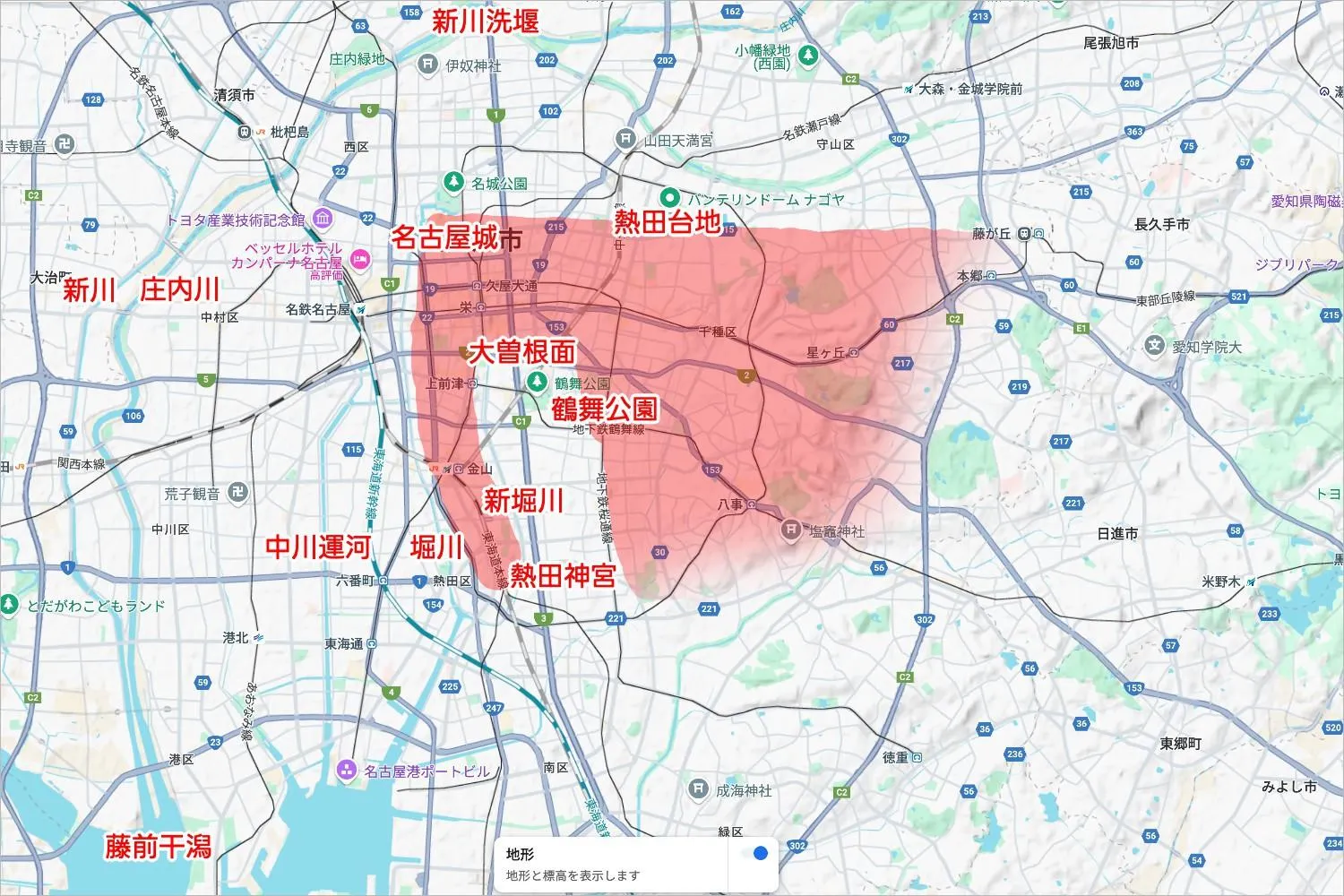
- Atsuta Plateau
- There's a rectangle-shaped Atsuta Plateau, with Nagoya Castle in the top left corner — it looks like an elephant facing left.
- The part that would be the elephant’s jaw is the Ōzone Surface. Temporary flow of the Yada River made this part lower in elevation.
- During earthquakes, this plateau tends to experience slightly weaker shaking. Nagoya Castle wasn't built here by accident — it’s because the ground is solid.
- If you ride the JR Chūō Main Line, you cross the plateau from left to right, and apparently, you can feel the change.
- Nagoya Station (low) → Kanayama (on the plateau) → Ōzone Surface (low) → Chikusa (on the plateau) → Ōzone Station (low).
- Back in the Edo period, Atsuta Shrine stood at a cape — everything south of it was ocean. Seriously.
- In the Edo period, to strengthen finances, the area was reclaimed into rice fields like Atsuta Shinden and Atsutamae Shinden.
- Ordered by Tokugawa Yoshinao in 1649.
- The "N-bancho" areas in Atsuta Ward, Minato Ward, and Nakagawa Ward were divided into 33 sections starting east from the shrine.
- The Hyakumagari Road (Hundred Bends Road) around here relates to pilgrimages visiting 33 Kannon temples.
- Reclamation is cheaper than landfilling — since you just reuse the seabed, the elevation stays low.
- Beyond this area (around National Route 23), land is landfilled, making it higher. That’s why places closer to the sea are actually higher. You can visibly notice the elevation difference around Tsukijiguchi Station.
- The only remaining tidal flat today is Fujimae Tidal Flat.
- In 1981, it was planned to be a waste disposal site, but the project was canceled thanks to protests, and it was registered under the Ramsar Convention in 2002.
- Migratory birds like dunlins visit here.
- Ayuchigata (年魚市潟, Ayuchi-gata) no longer exists due to reclamation and landfill.
- During the mid-Heian period, this area was called "Aichi," which is believed to be the origin of Aichi Prefecture’s name.
- Shōnai River
- A wild river.
- The Buei Dike (ぶえいづつみ) was built in 1400 to protect Kiyosu.
- The Okakoikadutsumi (御囲禍堤) was built in the Edo period to protect Nagoya Castle.
- Hori River
- An artificial river built during the Kiyosu relocation for Nagoya Castle in 1610.
- Later, it became so polluted that it was called the "River of Death."
- Shin River
- An artificial river created in 1784 during the Tenmei Flood Control project.
- The Shinkawa Araizeki (新川洗堰) allows overflow water from the Shōnai River to be diverted to Shin River during floods.
- Shinbori River
- A man-made canal completed in 1910.
- Since most of its water comes from treated sewage, and tidal movements cause stagnation, it smells pretty bad.
- The surplus soil from building it was dumped in Tsuruma Park.
- Another man-made canal, the Nakagawa Canal, was completed in 1924.
Thoughts When Looking at Maps of Nagoya - Facilities and Such
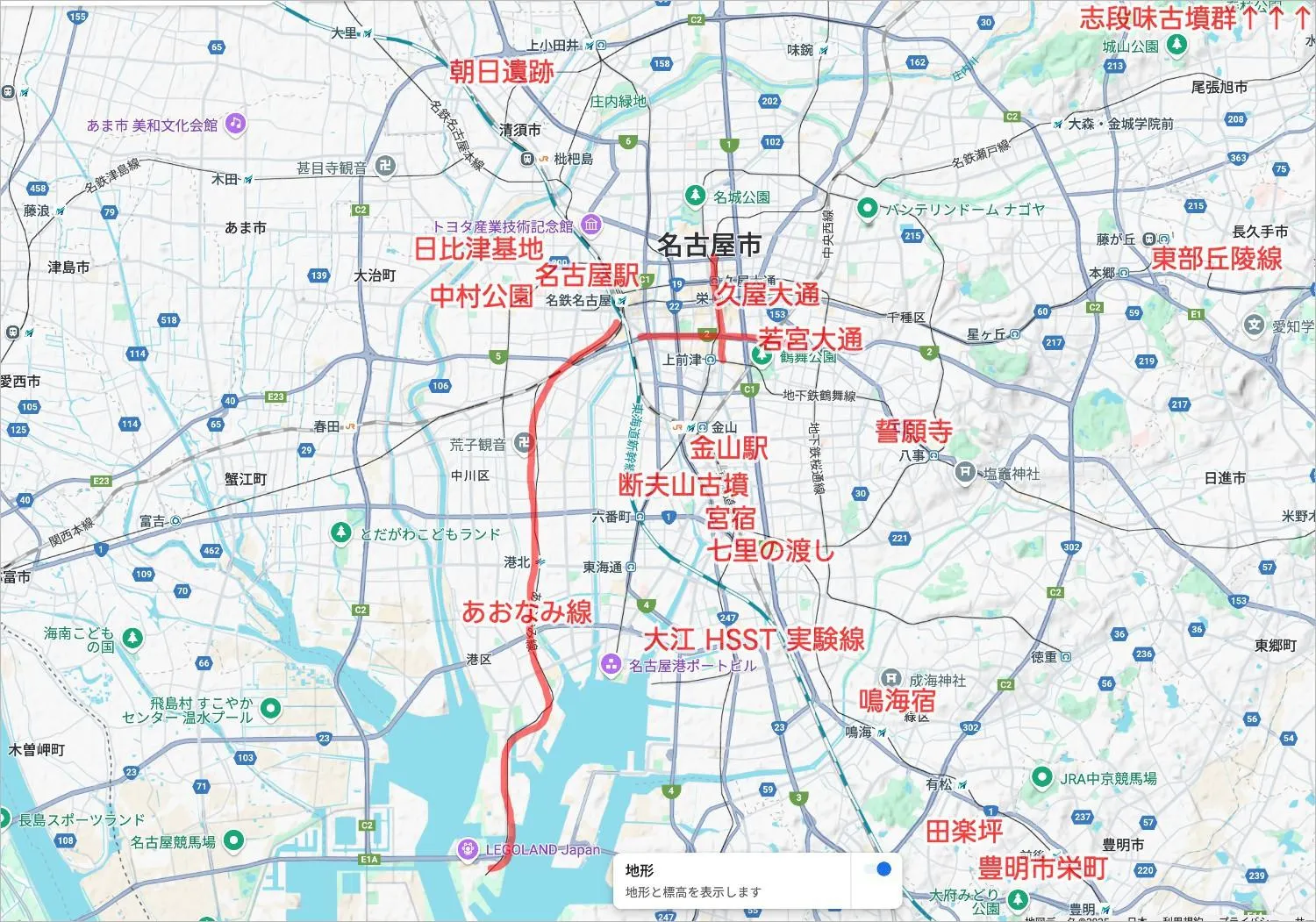
- Nagoya Station
- Originally built as Nago-ya Station in Sasashima in 1886, it was relocated as Nagoya Station in 1887.
- From 2034 onwards, the Chūō Shinkansen Maglev line is planned to open.
- Have you heard of Linimo? It's similar to the maglev — Linimo uses normal-conducting magnets, while the Chūō Shinkansen uses superconducting magnets.
- HSST Test Line
- Started in Ōe in 1991. It led to the opening of the Aichi Rapid Transit Tōbu Kyūryō Line (Linimo) in 2005.
- New Nagoya Station
- Opened in 1941, renamed Meitetsu Nagoya Station in 2005.
- Even with only 3 platforms and 2 tracks, it handles 900 trains a day. Amazing.
- Kanayama Integrated Station
- The next major terminal after Nagoya Station.
- Originally two separate stations (Meitetsu and subway) — they were combined in 1989 inspired by the World Design Expo.
- Aonami Line
- Connects Nagoya Station to Kinjō Pier.
- Originally a freight branch line from 1950. Turned into a passenger line with 11 stations in 2004.
- Name chosen by public contest — "Ao" (blue image color), "Na" (Nagoya), "Mi" (port).
- Hibitsu Base
- Where Kodama bullet trains rest at night.
- The site was once reserved for the "Bullet Train Plan" aiming to connect Tokyo and Shimonoseki in 9 hours — but WWII canceled it.
- Streetcars
- Began operation in 1898 from Sasashima to the prefectural office. Entire system abolished by 1974 as it became outdated.
- Some vehicles are preserved and displayed at the Retro Train Museum in Nisshin City.
- Asahi Ruins
- The largest ring moat settlement in the Tokai region, built for war defense.
- Many Ongagawa-style pottery pieces have been excavated.
- Ongagawa-style pottery originated in the Ongagawa River basin in Fukuoka Prefecture and spread with wet rice farming.
- Shidami Kofun Cluster
- A cluster of ancient tombs from various periods, called a microcosm of the Kofun period.
- Early to mid-4th century: Shiratori-zuka Kofun; mid-5th to early 6th century: Nishiokute Kofun; late 6th to 7th century: Shiratori Kofun Cluster.
- A female shaman-style haniwa was found in Nishiokute Kofun — Shidamiko-chan, a local character, is based on it.
- Danpusan Kofun
- In Atsuta Shrine Park.
- Legend says it's the tomb of Miyazu-hime, but in reality, probably the mother of an empress consort of Emperor Keitai.
- Seigan-ji Temple
- Birthplace of Minamoto no Yoritomo in 1147, who became shogun in 1192.
- Nakamura Park
- Birthplace of Toyotomi Hideyoshi in 1537, who became Kampaku (Imperial Regent) in 1585.
- Battle of Okehazama
- In 1560, Oda Nobunaga departed Kiyosu Castle, prayed at Atsuta Shrine, and defeated Imagawa Yoshimoto.
- This was a conflict over territory within Owari Province.
- Sakae-cho, Toyoake City was where Imagawa died.
- Okehazama North, Midori Ward was where Nobunaga washed Imagawa’s head — also called Dengakutsubo.
- Nagoya Castle (formerly Nagoya-jō)
- Around where today’s second enclosure of Nagoya Castle is.
- Originally a stronghold of the Imagawa clan, captured by Oda Nobuhide in 1538, and where Nobunaga grew up.
- Nagoya Castle
- After Tokugawa Ieyasu won the Battle of Sekigahara in 1600, became shogun in 1603, he began construction in 1610 and completed the main keep in 1615.
- Built to control the Toyotomi loyalists across Japan.
- Tokugawa Yoshinao lived there in 1649 and ordered the creation of Atsuta Shinden.
- Destroyed by B-29 bombers in WWII, rebuilt in 1959.
- Originally, Kiyosu was the center, but it moved due to the "Kiyosu Relocation."
- Atsuta Plateau’s stability was why this site was chosen.
- Kiyosu Relocation
- Kiyosu was flood-prone, so they moved the city.
- This move also led to the construction of the artificial Hori River.
- Nagoya Port
- Originally called Atsuta Port; renamed in 1907 after Atsuta Town was incorporated.
- Japan’s top port by cargo handled for 22 consecutive years. Huge economic impact — almost half of Aichi’s output.
- It’s massive, covering Yatomi Town, Tobishima Village, Nagoya City, Tokai City, and Chita City.
- Various things in 1937
- Moved Nagoya Station to its current location from Sasashima.
- Opened Higashiyama Zoo and Botanical Gardens.
- Nagoya Kanko Hotel opened.
- Nagoya Pan-Pacific Peace Exhibition was held, wishing for peace — but the Marco Polo Bridge Incident started the Second Sino-Japanese War that same year.
- 100-meter Roads
- Hisaya-Ōdōri and Wakamiya-Ōdōri. Built during post-WWII reconstruction.
- Building regulations to keep structures 2 meters away from roads and 1 meter from neighboring properties helped during reconstruction.
- Isewan Typhoon
- One of the "Great Typhoons" of the Showa era, struck in 1959.
- In Nagoya, it killed 1,851 people, submerging Minato Ward for over 20 days.
- That’s why there are flood-level markers all around Minato and Minami Wards.
- Gokaidō (The Five Highways)
- Roads developed by the Tokugawa shogunate.
- Designed for the "Tsubame-sei" system (relay stations for official letters and goods).
- Naruhama-juku (now Narumi Town in Midori Ward) was the 40th station on the Tōkaidō.
- Miya-juku (now Atsuta Ward) was the largest post station, 41st from Nihonbashi.
- Kuwana-juku (now Kuwana City, Mie Prefecture) was the 42nd station.
- Between Miya-juku and Kuwana-juku was the only sea route on the Tōkaidō, called the Shichiri no Watashi (Seven-Ri Ferry).
Thoughts When Looking at the 16 Wards Map

- Nagoya’s area ranks 4th in Aichi Prefecture — 1st is Toyota, 2nd Shinshiro, 3rd Okazaki.
- 1889: City system established.
- Ward system
- 1908: Higashi, Nishi, Naka, and Minami Wards created.
- 1937: Chikusa, Nakamura, Showa, Atsuta, Nakagawa, and Minato Wards created. Each ward had Japan’s largest population per ward — they split to manage administration better.
- 1944: Kita, Sakae, and Mizuho Wards created. (Sakae Ward was later destroyed in air raids and no longer exists.)
- 1963: Moriyama and Midori Wards created.
- 1975: Meito and Tempaku Wards created by splitting off from Chikusa and Showa Wards due to overpopulation.
Thoughts
Now, whenever I look at landforms, rivers, facilities, or wards around Nagoya, I can think something about them. OK!